

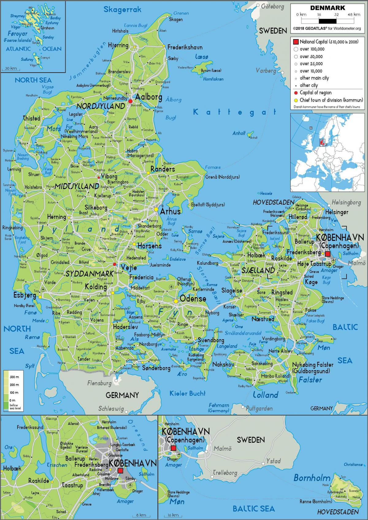
You can find on this page the Denmark geographical map to print and to download in PDF. The Denmark geographic map presents the topography, elevation, rivers, mountains, climate and physical features of Denmark in Northern Europe.

The Denmark physical map shows landform and geography of Denmark. This geographical map of Denmark will allow you to discover physical features of Denmark in Northern Europe. The Denmark physical map is downloadable in PDF, printable and free.
The physical landscape of Denmark is defined by low lying terrain, a major peninsula, Jutland, with several adjoining bigger and smaller islands. The largest island is Sjælland or Zealand, which is also the home island of capital Copenhagen, being connected by brides to the second largest Danish island of Fyn, and Sweden on the other side by the Øresund bridge built on the Øresund strait as you can see in Denmark physical map. The North Jutlandic Island on the northern tip of the Jutland peninsula is sometimes referred to as being part of the peninsula, however it is cut off from the mainland by the Limfjord making it a real island.
The country of Denmark is mostly flat, without any significant elevation, the average altitude is solely around 30 meters (100 feet), making it one of the flattest countries of Europe as its shown in Denmark physical map. The coastline has a healthy length of approximately 8700 kilometers which implies a rather erratic coastline, when comparing to the actual size of the country territory, which cannot be defined exactly, as it changes continuously due to erosion by the ocean and artificial structures. There a handful of rivers that collect excess water in the country, the longest one is Gudenå, flowing to the east/northeast from the central areas of the main peninsula.
Denmark, the southernmost of the Scandinavian countries, lies between the Scandinavian Peninsula and the vast expanse of the North European Plain as its mentioned in Denmark physical map. It covers most of the Jutland Peninsula and numerous islands in the Baltic, mostly in the Danish Straits. It is a flat country with a physical landscape formed by the glaciers of the ice ages, and a varied coastline with chalky cliffs, dunes and sandy beaches, as well as some striking fjords. The fjords in Denmark are long and mostly surrounded by low banks of sand dunes and rocks, which makes them perhaps less picturesque but provides excellent areas for water sports, particularly sailing. The Lim Fjord in the far north is the longest.
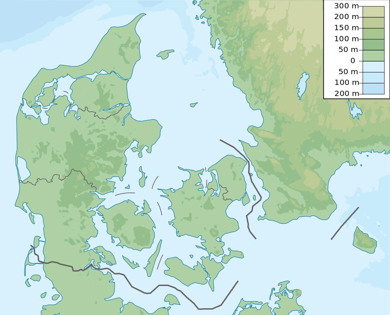
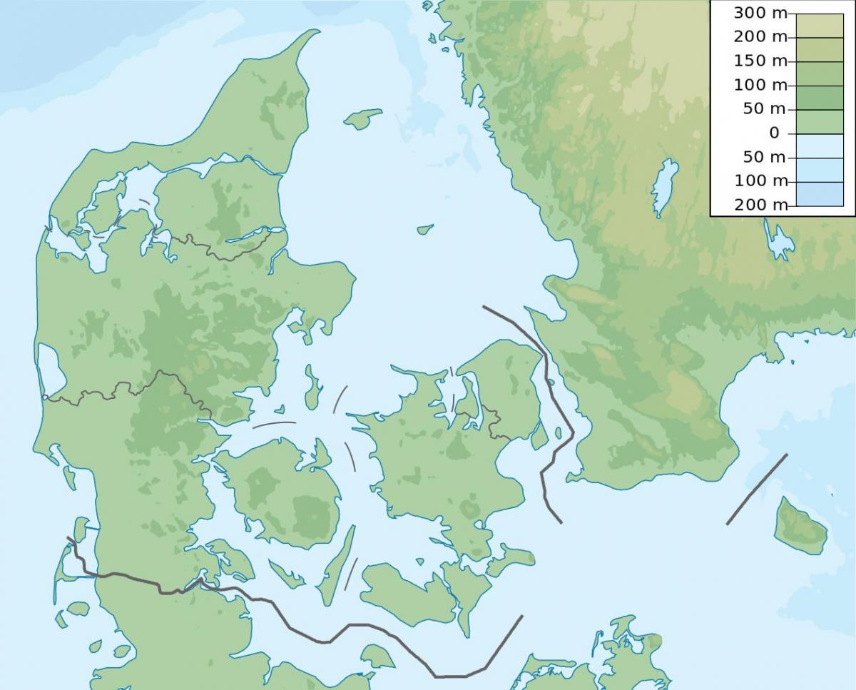
Denmark topographic map shows the physical features of Denmark. This topographical map of Denmark will allow you to discover landforms and geographical of Denmark in Northern Europe. The Denmark topographic map is downloadable in PDF, printable and free.
The country is flat with little elevation; having an average height above sea level of 31 metres (102 ft) as you can see in Denmark topographic map. The highest natural point is Møllehøj, at 170.86 metres (560.56 ft). The area of inland water is 700 km2 (270 sq mi). Phytogeographically, the Kingdom of Denmark (including Greenland and the Faroe Islands) belongs to the Boreal Kingdom and is shared between the Arctic, Atlantic European and Central European provinces of the Circumboreal Region. According to the World Wide Fund for Nature, the territory of Denmark can be subdivided into two ecoregions: the Atlantic mixed forests and Baltic mixed forests. The Faroe Islands are covered by the Faroe Islands boreal grasslands, while Greenland hosts the ecoregions of Kalaallit Nunaat high arctic tundra and Kalaallit Nunaat low arctic tundra.
The main topographic body of Denmark is formed by the Jutland Peninsula, which extends north of Germany from the Northern European Plain, reaching toward the southwestern corner of Sweden and separating the Baltic Sea to the east from the North Sea to the west. Most of this area is low-lying, the country highest elevation is below 600 feet as its shown in Denmark topographic map, but the glacial origins of the landscape have given it quite a variety of relief, with rolling low hills and lakes in some places, and flat farmland or salt-marsh bog in others. The extreme locations in Denmark are located in the east, west, north, and south of the country. Denmarklandscape shifts from open farmland to beech forest, from lakes to islands, from rolling hills to level plains, from drifting sand dunes to steep limestone cliffs.
Denmark proper is a lowland area that lies, on average, not more than 100 feet (30 metres) above sea level as its mentioned in Denmark topographic map. The country highest point, reaching only 568 feet (173 metres), is Yding Forest Hill (Yding Skovhøj) in east-central Jutland. The basic contours of the Danish landscape were shaped at the end of the Pleistocene Epoch (i.e., about 2,600,000 to 11,700 years ago) by the so-called Weichsel glaciation. This great glacial mass withdrew temporarily during several warmer interstadial periods, but it repeatedly returned to cover the land until it retreated to the Arctic north for the last time about 10,000 years ago. As a result, the barren layers of chalk and limestone that earlier constituted the land surface acquired a covering of soil that built up as the Weichsel retreated, forming low, hilly, and generally fertile moraines that diversify the otherwise flat landscape.
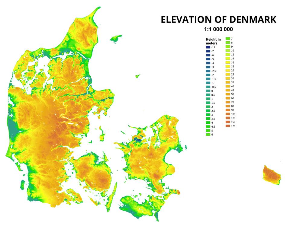
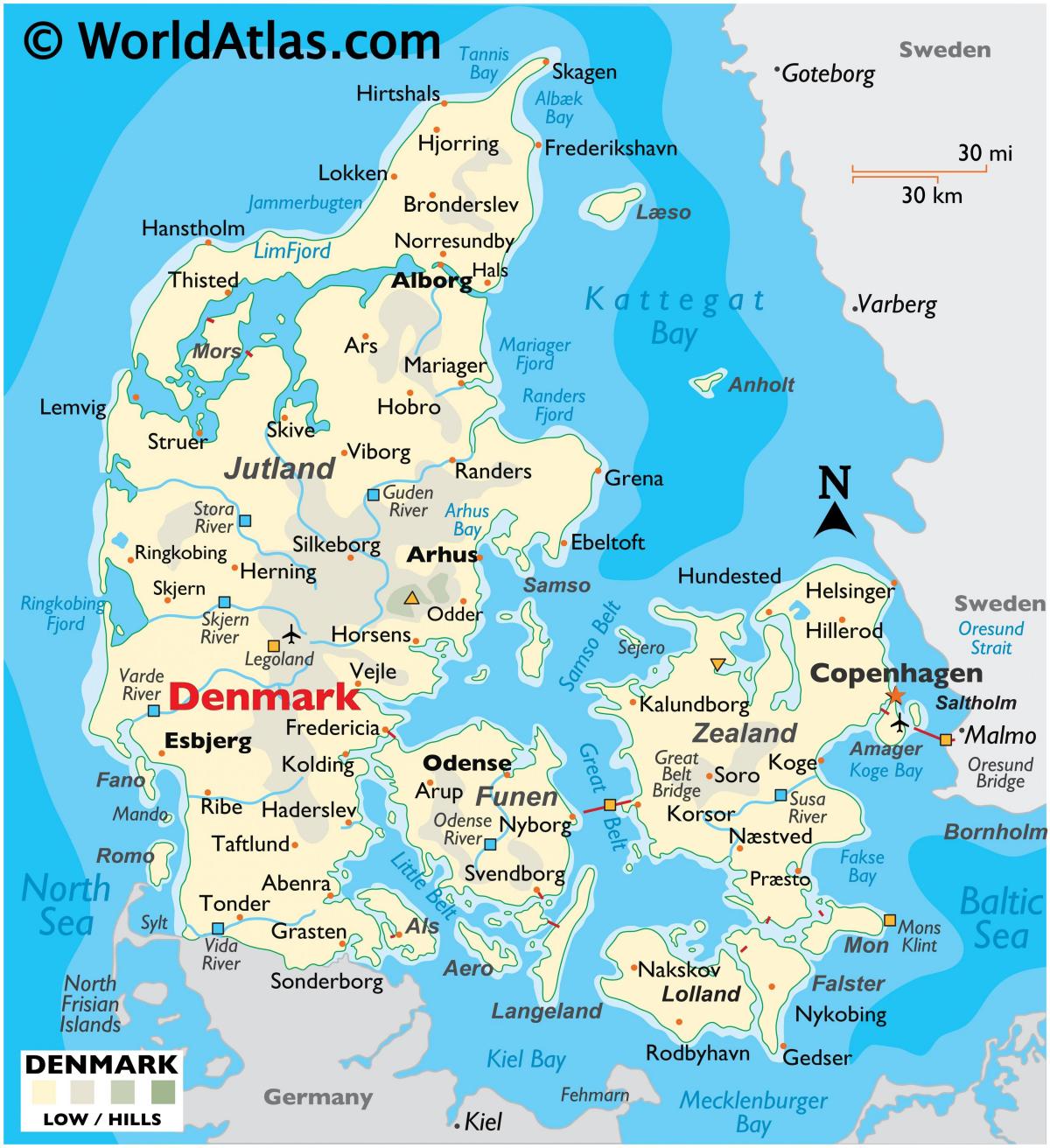
The Denmark elevation map shows the different altitudes of Denmark. This altitude map of Denmark will allow you to know where are the highest and lowest regions of Denmark in Northern Europe. The Denmark elevation map is downloadable in PDF, printable and free.
The terrain in Denmark is mostly low and flat with gently rolling plains. Its flat terrain is the main reason why it has one of the highest percentages of land suitable for growing crops than any other country in the world. At just 171 meters, Denmark highest elevation point is Møllehøj hill. This point is part of the Ejerbjerge Hills in the Eastern region of the Jutland Peninsula. Denmark northernmost point (excluding the Faroe Islands, and Greenland) is Skagens point (the north beach of the Skaw) at 57° 45' 7" northern latitude; the southernmost is Gedser point (the southern tip of Falster) at 54° 33' 35" northern latitude; the westernmost point is Blåvandshuk at 8° 4' 22" eastern longitude; and the easternmost point is Østerskær at 15° 11' 55" eastern longitude as you can see in Denmark elevation map. This is in the archipelago Ertholmene 18 kilometres northeast of Bornholm. The distance from east to west is 452 kilometres (281 mi), from north to south 368 kilometres (229 mi).
Møllehøj is the highest natural point in Denmark at 170.86 m (561 ft) as its shown in Denmark elevation map. It is in the Ejerbjerge hills in Skanderborg municipality, very close to Ejer Bavnehøj. The summit is marked with a millstone, a remnant of Ejer mill which was situated on the hill from 1838 to 1917. The mill had 8 sides and had an onion-shaped roof. New measurements made in February 2005 showed that Møllehøj was higher than both Yding Skovhøj (172.66 m including a Bronze Age burial mound on its summit, 170.77 m without) in Horsens municipality or Ejer Bavnehøj which had both been thought higher. These two highpoints natural heights are however respectively 9 and 51 cm lower than Møllehøj. It was officially recognised as Denmark highest elevation point in 2005.
The Lammefjord is a former body of water in Denmark at the base of the Odsherred peninsula. Previously a deeply branched arm of the sea leading west from the Isefjord, most of it is now reclaimed as agricultural land. The eastern third, outside the dyke at Avdebo, is still sea, but the name Lammefjord now usually refers only to the dry part west of the dyke. The sandy former sea bed is excellent agricultural land, especially for crops such as carrots and potatoes. The draining project begun in 1873, but it took until 1943 before the lowest elevations were pumped dry. Large parts of the fjord were shallow enough to be dry early on. In 1899 the Odsherred Railway opened across the western end of the fjord. The town of Fårevejle Stationsby grew up where the railway intersects that main road across the seabed; it serves as the administrative and mercantile center for much of the Lammefjord. The Lammefjord contains Denmark lowest dry elevation, at 7 metres (23 ft) below sea level. According to this list, it is also the lowest point in the EU (shared with Zuidplaspolder) as its mentioned in Denmark elevation map.
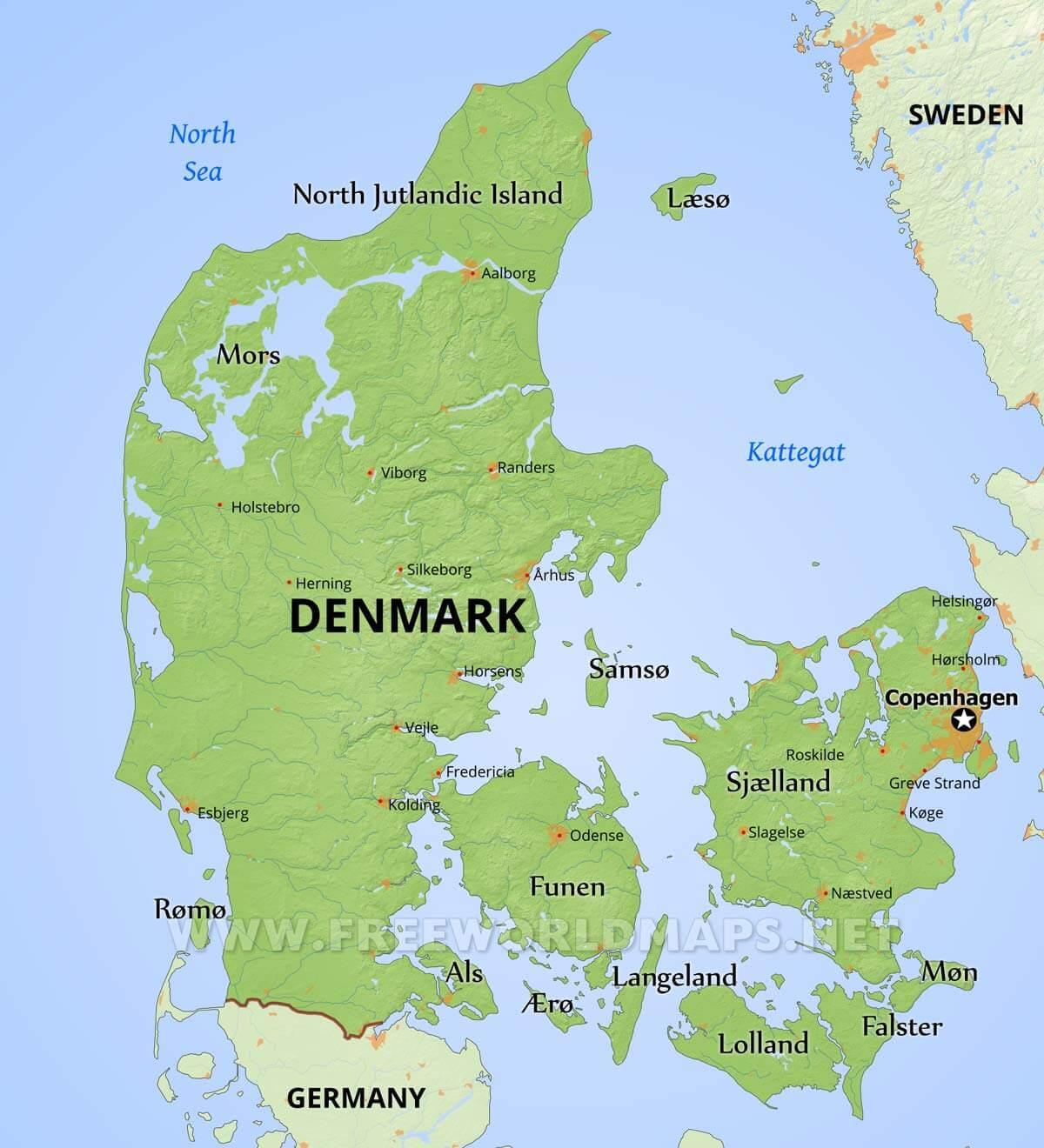
The rivers in Denmark map shows the principal rivers with their names of Denmark. The rivers map of Denmark will allow you to find the main rivers which flow in and through Denmark in Northern Europe. The Denmark rivers map is downloadable in PDF, printable and free.
The country of Denmark is drained by a dozen or so rivers, and the most significant include the Guden, Odense, Skjern, Stora, Susa and Vida - a river that flows along its southern border with Germany. The longest river in Denmark is the Guden at 160 km, (99 miles) in length as you can see in Denmark rivers map. The longest river in Denmark is the Gudenå. It flows a distance of 98 miles (158 km) from its source just northwest of Tørring, in east-central Jutland, through the Silkeborg Lakes (Silkeborg Langsø) and then northeast to empty in the Randers Fjord on the east coast. There are many small lakes; the largest is Arresø on Zealand. Large lagoons have formed behind the coastal dunes in the west, such as at the Ringkøbing and Nissum fjords.
The second longest river in Denmark is the Storå with 104 km (stor means big in Danish, so it is Big Creek or Big River) as its shown in Denmark rivers map. It originates near Ikast, a small town between Silkeborg (the city on the river Guden) and Herning. It flows to the northwest towards Holstebro, which is the biggest city on the Storå. Just before Holstebro there is a large dam, Vandkraftsøen, built in 1941 for a water power plant. This dam, as well as the entire lower section of the river, is a popular place for watersports. The Storå is one of the best Danish rivers for canoeing or kayaking. While the Guden is the longest, the Skjern river, or Skjern Å, is Denmark biggest river in terms of volume. It is only 94 km long and originates actually very close to Gudenå in Tinnet Krat. From there is flows westwards and enters the North Sea through Ringkøbing Fjord, near the town of Skjern. The lower section of the Skjern is a very precious natural area of wetlands and wildlife, previously considered for the so called Skjern National Park.
Kongeå, which means King river, flows roughly parallel to the Skjern in the south as its mentioned in Denmark rivers map. It starts near the small town of Vamdrup (near the bigger city Kolding) and enters the North Sea near Gredstedbro, just north of popular tourist town Ribe. It is 50 km long. In the past (until 1920) most of its flow marked the border between Denmark and Germany. The river which marks the border with Germany today (since 1920) is the Vidå, also known by its German name Wiedau. It enters the North Sea near Rudbøl, where it also forms a lake (Rudbøl Sø or Ruttebüller See). The river is 69 km long. Odense Å, the name of this river hints at its location not on the Jutland peninsula, but on the island Funen, where it flows through its main city Odense. The Odense Å is 60 km long and known for cruises and excursions.

The mountains in Denmark map shows the principal mountains with their names in Denmark. The mountains map of Denmark will allow you to find the main mountains ranges and highest mountains of Denmark in Northern Europe. The Denmark mountains map is downloadable in PDF, printable and free.
There are 1243 named mountains in Denmark. The highest and the most prominent mountain is Yding Skovhøj. Rytterknægten is the highest point on the Danish island of Bornholm at 162 metres (531 ft) above sea level as you can see in Denmark mountains map. The bierg is situated on a wooded bedrock of gaiter formations in the middle of Almindingen forest. Aakirkeby is located about 5 kilometres (3.1 mi) to the southeast. Ejer Bavnehøj (Danish pronunciation: [ɑɪ̯ɐ ˈbɑʊ̯nəhɔɪ̯ˀ], also spelled Ejer Baunehøj) is the third-highest natural point in Denmark (170.35 m). It lies in the southern part of Skanderborg municipality, between the villages of Riis and Ejer. At its summit is a 13 m tall tower, built in 1924, commemorating the reunion of the south of Jutland with the rest of Denmark after the First World War.
Vejrhøj is located in Odsherred and is one of Zealand most impressive burial mounds. Its peak lifts you 121 meters above sea level and is Zealand third highest point (the highest is Gyldenlove High with 125.5 meters) as its shown in Denmark mountains map. If you climb the historic burial mound, you will be rewarded with a panoramic view of the Sejerob bay, the Lammefjord and the entire Odsherred. Vejrhøj is the highest point of the mountain, Vejrhøjbuen, which in turn forms one of three ‘bows’ on Odsherred. Troldemose Bakke (Troldemose Bakke) is a hill (class T - Hypsographic) in Central Jutland (Vejle), Denmark (Europe) with the region font code of Americas/Western Europe. It is located at an elevation of 31 meters above sea level. Its coordinates are 55°43'60" N and 9°57'0" E in DMS (Degrees Minutes Seconds) or 55.7333 and 9.95 (in decimal degrees). Its UTM position is NG57 and its Joint Operation Graphics reference is NN32-02.
Trehøje is three hilltops, each being 127 metres high, located in the middle of the scenic Mols Bjerge National Park. If you climb the three hilltops, you can experience a view like no other. The landscape rises up steeply from the coast, offering surprisingly pleasant panoramas of Djursland undulating landscape on one side and the Kattegat sinuous coast on the other. Kløveshøj is a mountain in Kalundborg and has an elevation of 99 metres. Kløveshøj is situated nearby to Nørager, and east of Frihedslund. The prominence is 67m/220ft as its mentioned in Denmark mountains map. There is a trail leading to the summit. By elevation Kløveshøj is. # 24 out of 188 in Region Zealand.
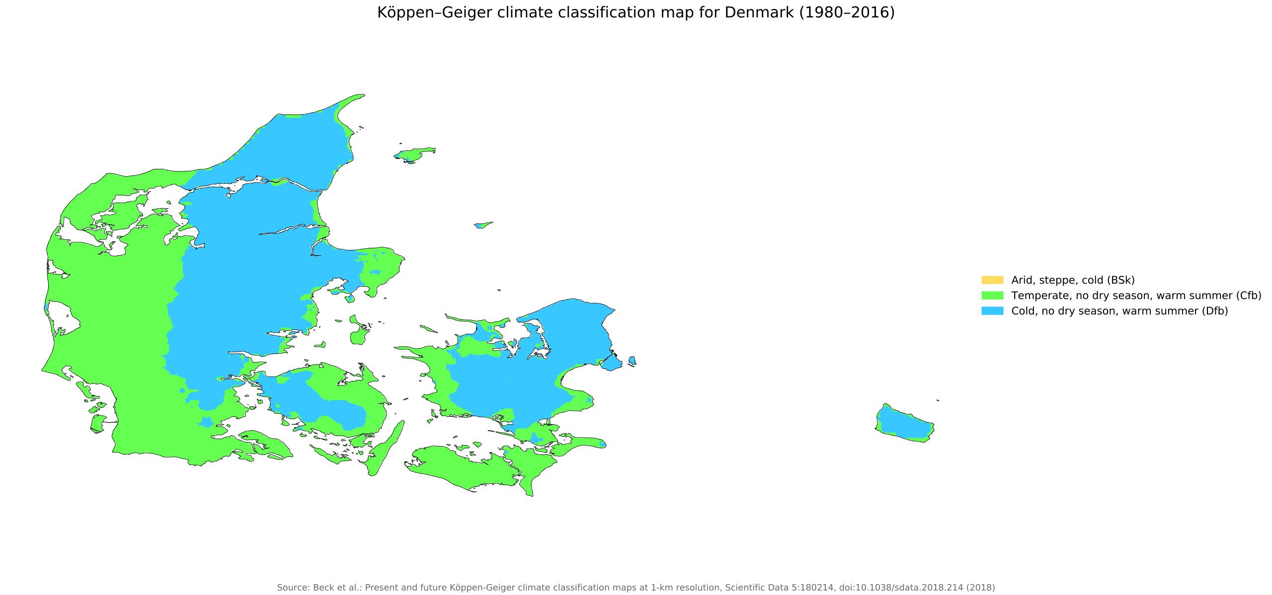
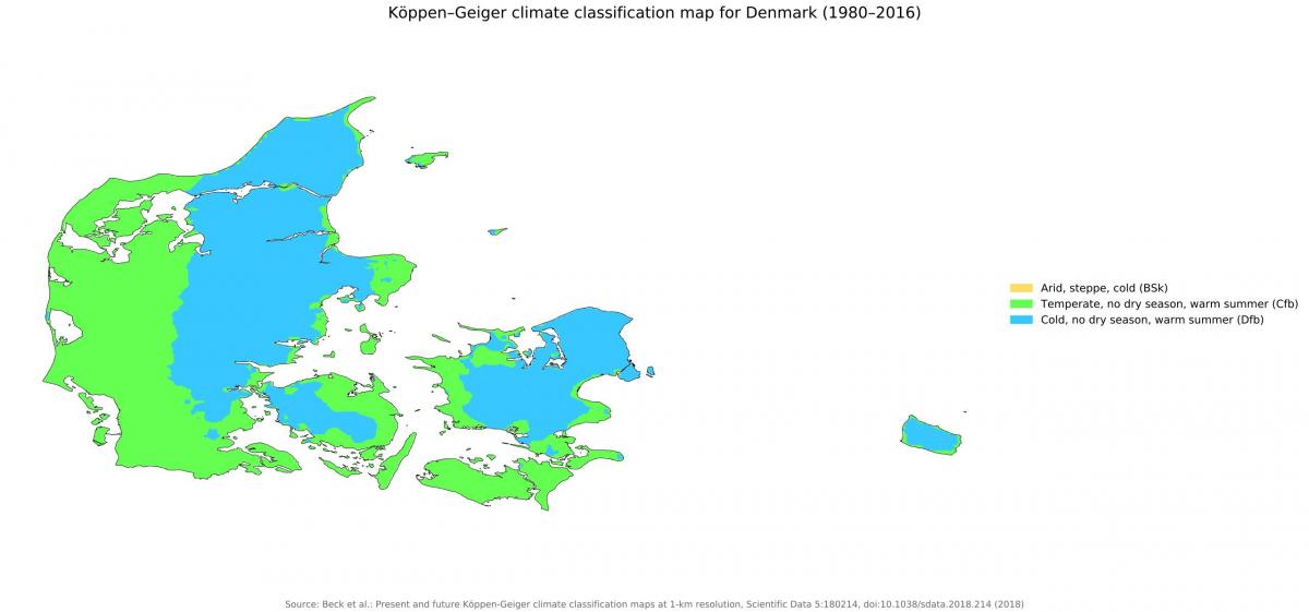
The Denmark climate map shows average temperature and climate zones of Denmark. This climate map of Denmark will allow you to know weather, average precipitation, average sunshine and different climates of Denmark in Northern Europe. The Denmark climate map is downloadable in PDF, printable and free.
In Denmark, a European country located north of Germany and belonging to Scandinavia, there is a temperate climate, cold in winter and mild or pleasantly warm in summer. Although it is located at high latitudes, it is affected by ocean currents, so it is not as cold as one might think. In fact, clouds, humidity, rain and wind are predominant. The country is small and flat, so there are little climatic differences between the areas, however, the western coasts of the Jutland peninsula are milder, windier and rainier than the rest of the country. Average temperatures are around 1/2 °C (34/36 °F) in January and February and 17/18 °C (63/64 °F) in July and August as you can see in Denmark climate map. Denmark is not a very sunny country, however, the east is sunnier than the west, and in summer there is a good number of sunshine hours, also thanks to the length of the days. On average, there are about 1,750 hours of sunshine per year in western Jutland and 2,000 hours on the island of Bornholm.
Precipitation is not abundant, but it is frequent and well distributed throughout the year because Atlantic depressions occur in all seasons. However, it is moderate in the west-central part of the Jutland peninsula, where it reaches or exceeds 800 millimeters (31.5 inches) per year (see Vestervig, Esbjerg), while it gradually drops in the center and east, to 600/650 mm (23.5/25.5 in) per year, and even below 500 mm (20 in) in Bornholm as its shown in Denmark climate map. Snowfalls occur from November to the first half of April. In one year, there are 20/25 days with snow. Even in winter, the ground can be snow-free for long periods, as is also the case in southern Sweden and on the Norwegian west coast. On the other hand, when the country is reached by easterly currents brought by the Siberian High, the temperature suddenly drops, and may plunge several degrees below freezing, down to about -20 °C (-4 °F) in the worst moments. These cold periods, which are becoming rarer due to global warming, may last for a few days, usually less so than in Sweden or Finland.
Winter in Denmark is cold, with an average temperature of January and February just above freezing (that is, zero degrees Celsius or 32 degrees Fahrenheit). The days are very short (in December, the sun sets at 3:00 in the afternoon), and temperature fluctuations between day and night are little. On the western coast and on the small islands, winter is a little milder, with minimum temperatures around freezing, but with a lot of wind, especially in the north. Apart from that, temperatures are fairly uniform across the country. Spring is initially cold, and remains cool still in May: the maximum temperature in Copenhagen is on average about 12 °C (53 °F) in April and 16 °C (61 °F) in May as its mentioned in Denmark climate map. However, spring is the relatively driest season of the year. In autumn, the weather is dull and rainy, and at times windy. In November, the amount of sunshine is minimal as in winter. In Copenhagen, the maximum temperature in September is already about 18°C (64 °F), then it drops to 12 °C (54 °F) in October and to 8 °C (46 °F) in November.